2019 Texas Grazing Preview

2019 Texas Grazing Preview: Focus on the Panhandle and Rolling Plains

It’s finally April and we here at Livestock Wx are excited to finally say adios to winter and get ready for all the fun spring weather.  In anticipation of the growing season, we thought it would be good to start a grazing preview for the major cattle producing states.  This week, we’re starting with Texas and more specifically the Texas Panhandle and the Rolling Plains.  We will add more regions and states in the coming weeks.

In some ways, the Panhandle and Rolling Plains are still recovering from last year’s drought, which clung to the region from the fall 2017 through spring 2018.

“I would say a resounding yes. The Panhandle is in much better shape now than they were then. They received a good rain last week [week of: March 25th] which further reduced their drought status. (see the comparison of the U.S. Drought Monitor below)  Having said that, they can ALWAYS use more rain up there,” said Clark B. Neely, Ph.D., Assistant Professor and Extension Small Grains and Oilseed Specialist at Texas A & M AgriLife Extension.    

Portions of the High Plains (around Amarillo, Texas) began drying out during the winter months, and Neely said some cattle were pulled off of wheat fields early, from limited moisture.

2019 Drought Flip-Flop

U.S. Drought Monitor for February 12, 2019

U.S. Drought Monitor for April 9, 2019

“The state of Texas; as a whole has started to trend drier as we enter into the spring,” Neely noted, “But subsoil moisture should still be excellent in most cases, except for portions of the High Plains that were drier earlier, and now areas where drought is creeping into Southwest Texas.”   The below images show percent of average precipitation from October 1 to present and temperature departures from January to April that show the areas Neely is referring to.

Texas percent of average precipitation for October 1 – April 2019

Texas departure from average temperatures from Jan 2019 – April 2019

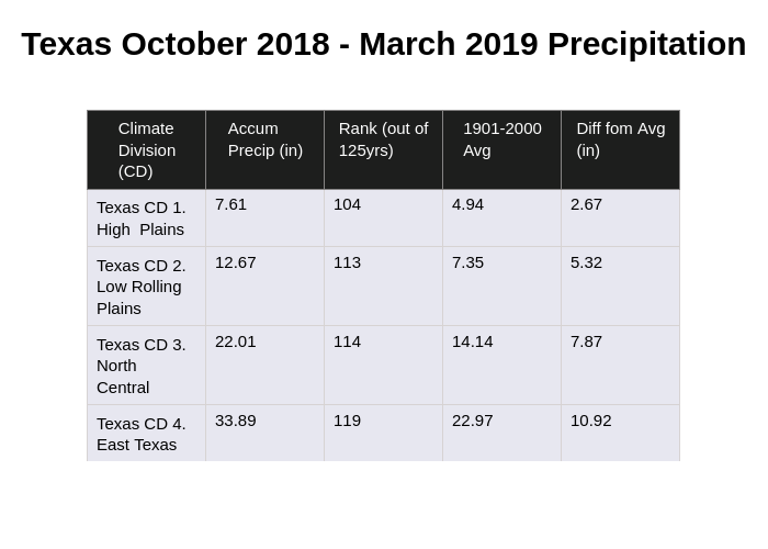
Looking at the precipitation by ranking from October 1 to March, we see a number of Texas Climate Divisions saw precipitation amounts that ranked in the top 100 years (out of 125).  Exceptions were primarily in South Texas.  For the Panhandle and Rolling Plains, October to March represents about 40% of the total annual precipitation so we still have a ways to go, but this is a good start.

April to July represents about 50% of annual precipitation so if the trends continues this could be a good sign for grass production this year.

Location of the 10 Texas Climate Divisions (CDs)

Plot 49

While the Panhandle has seen some late breaking rainfall, if we look at the 90-day evapotranspiration rates (the amount of moisture being evaporated from the plants and soil), we see higher than average rates in the Panhandle and Far West Texas.  Evapotranspiration rates across the Rolling Plains have been about normal to below normal.  Looking at evapotranspiration rates always completes the story even if it’s painful and checks our enthusiasm.

There is still a lot of precipitation ground to cover so this is just the beginning.

We will cover more regions of Texas next week and include another state or two from the Plains.

90-Evapotranspiration Rates (Jan-Apr) in inches (departures from the long-term average)
Share on facebook
Share on google
Share on twitter
Share on linkedin
Share on pinterest

Soggy Fields Due to Snowmelt and Rain


Livestock Wx

Soggy Fields Due to Snowmelt and Rain - Severe Storms Too

Soggy fields and extensive inundation due to snow melt, river flooding, and heavy rain can be expected over parts of the central U.S. over the next week. The first system (1) produced heavy snow and blizzard conditions over the Upper Midwest, especially South Dakota. 

This snow will rapidly melt over the next week resulting in extensive ponding of water, inundation of fields, and flooding of tributaries leading into the Missouri and Upper Mississippi Rivers. A new flood crest is likely along the Missouri River due to melting snow next week.

Keep alert for severe storms tomorrow over the South Central U.S. where a significant severe storm outbreak is expected.

The threat for severe storms will shift east on Sunday.

Share on facebook
Share on google
Share on twitter
Share on linkedin
Share on pinterest

By the Numbers for the Week of April 15, 2019

By the N#mbers

By the Numbers for the Week of April 15, 2019

  • 50/50 or Part of West TX Blew Away on Wednesday

    On Wednesday (April 10), strong winds and blowing dust caused numerous crashes around Lubbock. Wind speeds of 40 to 50 mph and gusts over 70 mph were observed. Coupled with low humidity and temperatures in the low 90s, made for extreme conditions and resulted in a red flag warning being issued by the National Weather Service. In Wyoming they call days where the wind speed approaches the high temperature 50/50 days, meaning 50 degrees for the high (that’s warm in Wyoming) and 50mph winds (also mild for Wyoming). Over the next week, conditions should be relatively mild over most of TX and OK, however, mild temperatures are usually accompanied by rainfall and there should be a lot of it (see below) over the next week. The exception to all this will be Far West TX, which is expected to see above average temperatures and little to no rainfall.

  • 7-Day Rainfall

    Several soaking-rain systems will hit the South-Central U.S. over the next week. The first will arrive this weekend with another later next week. This will result in extremely heavy rain and the prospects for flooding. A large portion of TX and OK could see 2 or more inches of rainfall.

  • March Temperature and Precipitation Rankings

    NOAA released its temperature and precipitation rankings for March this week. The Edwards Plateau, the Rolling Plains, Southwest OK and into Northeast OK all saw below-average temperatures for the month. For precipitation, the big winner was the TX/OK Panhandle, which came in as the 103rd and 102nd (respectively) wettest March on record (out of 125 years). If you’re interested that’s worth about 1.4”of precipitation for the TX side and about 2” of precipitation for OK.

  • U.S. Drought Continues to Decline: Lowest percentage of the U.S. in drought ever reported by the Drought Monitor

    This week, the U.S. Drought Monitor reporter a little over 4% of the Contiguous U.S. in drought. That is lowest percentage since the Drought Monitor stared in 2000 and just beat out May 23, 2017 for the title. TX saw a decrease of about four percentage points considered in drought from last week while no area in OK was in drought. This is good news but we are just starting to see warmer temperatures and getting into the growing season so this is likely the lowest we will see for some time. Areas to watch going forward will be Central TX, South TX along the border, and Far West TX.

Share on facebook
Share on google
Share on twitter
Share on linkedin
Share on pinterest