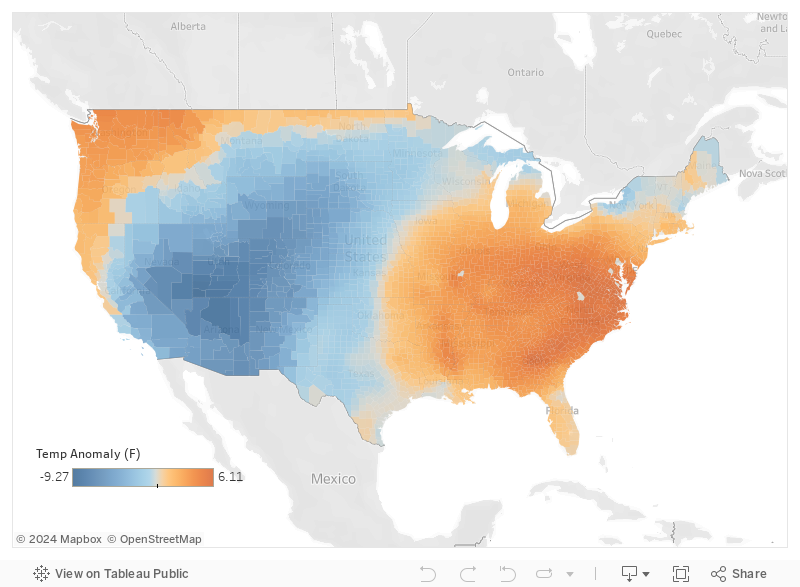
NMME Summer Outlook

The North American Multi-Model Ensemble (NMME) monthly forecast was updated this week.  The NMME is an ensemble, or average, of numerous government and university climate models.

July Temperature

NMME guidance has just been updated. Model guidance indicates an interesting cooler summer, perhaps reflecting currently-high soil moisture, over Kansas and surrounding states. Hotter-than-normal temperatures are called for elsewhere, especially over the Western U.S.

August Temperature

September Temperature
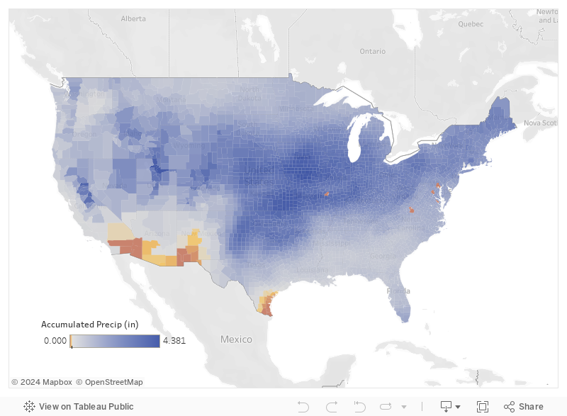
July Rainfall

Wetter-than-normal conditions are forecast over California and other parts of the Western U.S. in July, spreading into the Northern Plains during late summer.

August Rainfall

September Rainfall

Share on facebook
Share on google
Share on twitter
Share on linkedin
Share on pinterest

Start To Hurricane Season And Something To Watch


Hurricane season officially started as of June 1st. However, statistics indicate that activity is usually low until later in the summer. (red-outlied box indicates past June activity).


Tropical development in June typically develops "close in" -- within the warmer waters of the Gulf of Mexico and Caribbean Sea.


Currently, there is a pool of higher ocean heat content within the Caribbean Sea extending into the Gulf of Mexico.


A broad area of low pressure is producing disorganized shower and thunderstorm activity over the Bay of Campeche. This system is forecast to move northwest towards the northeastern coast of Mexico and could become a tropical cyclone before it moves inland.


Looking ahead, there are some signs that tropical moisture could be transported inland. The following image (below) depicts the transport of high moisture (as indicated by the dew point) from a tropical source inland. If this occurs, inland rainfall would be enhanced.


Ample atmospheric moisture, combined with a series of frontal boundaries, could point towards very heavy rainfall over the next week.

Share on facebook
Share on google
Share on twitter
Share on linkedin
Share on pinterest

Active Weather (Again) This Week

Holiday Weekend Tornado Outbreak

Tornadoes produced widespread damage across parts of the eastern corn belt yesterday, including the Dayton area. There were close to 50 reports of tornadoes on Monday.

Adverse Weather Ahead

Adverse weather impacts can be expected along a series of frontal boundaries across the nation early this week.

Severe Storms - Moderate Risk

There is a moderate risk for severe storms across the central corn belt today. Strong tornadoes are possible within and close to this region. Damaging winds and large hail will also accompany the strongest storms. The greatest chance for severe weather will extend from this afternoon into tonight.

Heavy Rainfall Potential

Strong storms will produce heavy rain and the possibility for flooding -- both urban, flash, and major river.

Major Flooding

Many rivers, especially the Mississippi, Lower Missouri, and Arkansas are experiencing major (purple squares) flooding.

Excessive Heat

Unusually hot and dry weather dominates the Southeast U.S. At least six Southeast cities have tied or set new all-time May records. Five of those six cities tied/set their May record on multiple days.

Share on facebook
Share on google
Share on twitter
Share on linkedin
Share on pinterest

More Excessive Rain – Severe Storms – and Flooding

More Excessive Rain – Severe Storms – and Flooding

Rainfall over the Last 7-Days

Widespread rainfall of 8' or more has been observed over the last week.

Additional Excessive Rain - Severe Storms - and Flooding

The central part of the nation will continue to experience extremely heavy rain, severe storms, and widespread flooding not only this week but next as well.

7-Day Accumulation Rainfall Forecast

The forecast over the next week is calling for up to 3" of rainfall over a large area of the Central U.S. adding to already very wet conditions and flooding in the region.

Risk of Heavy Precipitation

NOAA is calling for a moderate to weak risk of heavy precipitation over the Central U.S. between May 30th-June 5th. Slight risk has a likelihood of 20%-40% and Moderate risk has a likelihood of occurrence of 40%-60%.

Two-Week Forecasts

15-Day Temperature Anomaly Forecast: May 23-Jun 6

15-Day Accumulated Precipitation (in) Forecast: May 23-Jun 6

15-Day Temp-Precip Forecast for the 12 Major Feeder Cattle-Producing States

9 out of the 12 states will see state-wide temperatures below normal over the next couple of weeks.  WY, SD, NE, KS, OK, IA, and MO will see a average statewide accumulated precipitation above 2.0″.  NM will see very little precipitation but below-normal temps.

Tornadoes – Heavy Rain – Flooding

Tornadoes – Heavy Rain – Flooding

Severe Storms

Widespread severe weather was reported last week from Texas, across Oklahoma, into Kansas. There were over 20 reports of tornadoes (red dots).

Extreme Rainfall

The heaviest rain fell from North Oklahoma into Southeast Kansas. In some areas over 6 inches of rain was observed.

Flooding

The extreme rainfall has resulted in widespread flash flooding and field inundation. In addition, major rivers are in flood, especially near communities in red(moderate) or purple (major flooding).

More Rain On The Way

The weather system that has produced all the adverse weather will remain in the area for a while. The result will be more heavy rain over parts of the middle U.S. Here is the rainfall forecast for the next 7 days.

Week 2 - Not Much Better

The extended outlook for the end of the month into early June indicates continued wet weather (green shades) over the Midwest.

Share on facebook
Share on google
Share on twitter
Share on linkedin
Share on pinterest

High Risk Tornadoes Today

High Risk For Severe Storms Today

There will be a major severe storm outbreak today (bottom-left) across the central Plains. The risk will spread east on Tuesday (bottom-right).

Heavy Rain and Flooding


Heavy rain will result in widespread field inundation, urban and flash flooding, and flooding of low spots.

Share on facebook
Share on google
Share on twitter
Share on linkedin
Share on pinterest

Severe Storms and Heavy Rainfall

Very active weather, with severe storms, heavy rain, and flooding, can be expected over the middle of the nation over the next 3 days. 

Severe Weather Outbreak

Severe storms are likely tomorrow, including tornadoes over parts of the Plains, especially western sections of Oklahoma and southern section sof Kansas.

Heavy Rainfall

The same weather system will produce extremely heavy rainfall -- over 5 inches in spots -- from Oklahoma, across Kansas northeast.

Soggy Fields and Flooding

All of the heavy rain will result in widespread inundation of fields, urban and flash flooding, and river flooding.

Share on facebook
Share on google
Share on twitter
Share on linkedin
Share on pinterest

June and Summer Outlooks

June Temperature Outlook

NOAA just updated the temperature and rainfall outlooks for June and the 3-month summer period.

June Temperature Outlook

Blue = Colder Than Normal
Brown = Warmer Than Normal

June - July - August Temperature Outlook

Blue = Colder Than Normal
Brown = Warmer Than Normal

June Rainfall Outlook

Green = Wetter Than Normal
Brown = Drier Than Normal

June - July - August Rainfall Outlook

Green = Wetter Than Normal
Brown = Drier Than Normal

Science Behind The Forecast

There are a number of factors influencing the 1- and 3-month outlooks. These include: Residual High Soil Moisture (below). The NOAA outlook expects current high soil moisture over the middle of the nation to hold temperatures in check well into the summer. In addition, upper soil moisture will be transported into the lower atmosphere via evapotranspiration thereby enhancing chances for summertime thunderstorms.

Trends

Trends: Research indicates summers are getting hotter across most of the U.S.

Climate Models: 

Outlooks, especially later in the forecast period, align closely with long-lead climate models, especially the North American Multi-Model Ensemble (NMME).

El Niño and other teleconnections

Models indicate a weak to borderline-moderate El Niño through the summer months.  In addition, the Madden Julian Oscillation (MJO) is expected in influence weather patterns in June. 

Share on facebook
Share on google
Share on twitter
Share on linkedin
Share on pinterest

More Active Weather, More Heavy Rain, More Impacts

More Active Weather, More Heavy Rain, More Impacts

Active Wx Ahead

A series of frontal boundaries between two different air masses will serve as a focus for heavy rain, severe storms, and additional flooding through the weekend.

Contrasting Air Masses

7-Day Accumulation Forecast
(May 16-May 23, 2016)

Spring Planting

Cool and wet weather have hindered spring planting. Unfortunately, future wet conditions likely will continue to impact Midwest spring operations for at least the remainder of May. See our story on corn planting delays.

Impact on Rivers

The Missouri and Upper Mississippi River are currently falling. Additional rainfall over the next week will likely result in secondary crests. While it is unlikely that rivers will reach recent-past high water levels, future rises could once again produce adverse impacts.

Excessive Rainfall

Due to currently-wet soils, excess runoff will produce soggy fields and significant flooding on smaller tributaries and low spots. Saturday's excessive rainfall potential.

Extended Outlook

The strong temperatures contrasts that are serving as a focus for heavy rain are expected to persist through at least the next few weeks. This will result in a continuing risk for heavy rain over parts of the Plains and Midwest through the remainder of the month.

Extended Period of Unsettled Weather Ahead

Extended Period of Unsettled Weather Ahead

Wx Hazard Outlook

A potent weather system will slowly move across the middle of the nation heading into the weekend with a multi-day threat for severe storms and heavy rainfall.Take a look at all the potential impacts expected!

Severe Storm Risk

Note the chance for severe storms, mainly Friday through next Tuesday.

7-Rainfall Forecast

A broad area of 2 to 3 inches of rain is forecast from the South Central U.S. into the Midwest. Areas of heavy rain will result in soggy fields and potential delays in spring field operations.

River Forecast

The Mississippi River is falling to around Memphis with rises further downstream. Most of the Missouri River is holding steady or falling. Note how future rainfall is split between the Missouri and Mississippi river basins. Future rainfall is likely to result in a slowing of the current river recession or additional rises. However, any future crests on mainstem rivers should not near recent-past levels. 

Risk of Heavy Precipitation

Taking a look at the extended outlook for the period of May 22nd through the 28th -- the Central U.S. could remain active with a continuing chance for significant rainfall.

Share on facebook
Share on google
Share on twitter
Share on linkedin
Share on pinterest