In its Second Year Grass-Cast Continues to Improve: See What’s New in 2019
- Amy G. Hadachek
- June 5, 2019
- 1:55 pm
A good tool in the tool box…is how Grass-Cast is being described, to predict how much grass ranchers might have for the grazing season. Grass-Cast is a website tool which provides forecasts of grassland plant production for ranchers in the Great Plains, beginning in spring and updating the forecasts every two weeks.
“Hopefully, Grass-Cast helps them plan better throughout the season for their grazing. That’s true in both wet and dry times. In drought, we try to be more conscientious about our dry resources, but it’s also true in our wet years, such as…if you’re expecting above average precipitation, what can you do to maximize your resources…” said Laura Edwards, South Dakota State University Extension state climatologist, who was instrumental in providing guidance for tailoring Grass-Cast to ranchers.

Click here to see the latest Grass-Cast forecast
May 28th Forecast
How Grass-Cast Works
Grass-Cast ( http://grasscast.agsci.colostate.edu ) offers three different “what if” scenarios, which may help livestock producers in making their stocking rate decisions, drought management plans, and triggers for implementing it. The maps show the potential range of grassland production (relative to an area’s long-term average production) which depends on whether rainfall over the remaining growing season is in one of these three categories: below-normal, near-normal, or above-normal. “The hope is that Grass-Cast can reduce some of the uncertainty that ranchers face every spring when they have to guess about how much grass will be available for their livestock to graze during the upcoming growing season,” said Dannele Peck, Director of the USDA Northern Plains Climate Hub in Fort Collins, Colorado.

Above-Normal Precipitation Outlook for June-July-August

Near-Normal Precipitation Outlook for June-July-August

Below-Normal Precipitation Outlook for June-July-August
What it Analyzes
“We estimate ANPP (above-ground net primary productivity, which you can think of as pounds per acre of vegetation at the peak of the growing season.) More importantly, we estimate how much ANPP during the upcoming growing season might differ from the long-term average for a given area. Our estimates are based on current weather (up to the date the forecast is made), and seasonal precipitation outlooks for the upcoming summer,” said Bill Parton, Senior Research Scientist in the Natural Resource Ecology Lab, and Professor Emeritus at Colorado State University. Parton and Peck developed Grass-Cast with colleagues from USDA, and with several different land-grant universities. Parton has spent the last 40 years studying primarily how weather, climate, and human activities like grazing influence grassland ecosystems.
Expanded Coverage: North Dakota to Texas
In an exciting addition, Grass-Cast this year was expanded to also cover grassland areas of the Southern Plains, including western Kansas, western Oklahoma, north Texas, and eastern New Mexico, in addition to the states it was introduced in last year (including: the Northern Plains—eastern Colorado, eastern Wyoming, eastern Montana, western North Dakota, western South Dakota, and western Nebraska.)
“The Grass-Cast team focused on the Great Plains region for two reasons. First, this region is where much of the nation’s rangeland cattle graze during the summer. Second, this region’s weather is highly variable, especially precipitation, so it has a big impact on year-to-year changes in grassland plant production,” said Parton. In addition to expanding the regional coverage, Peck says they also improved how readers see Grass-Cast: http://grasscast.agsci.colostate.edu Last year they used a county-level scale. This year, they have a finer, sub-county scale.
How to Use Grass-Cast
The website also offers a webinar, as well as ‘FAQ’s’ (frequently asked questions.) Grass-Cast caught plenty of attention when it was drier last year. Meanwhile, developers revamped it and added new features on the website to make it easier to understand.
It’s all about pounds per acre, which depends on how much water is moving through the soil and plants, also known as evapotranspiration (ET.). “Low levels of ET are a sign that vegetation might be struggling to grow. Higher levels of ET are a sign that vegetation is likely greener and growing more vigorously. So if we have daily weather data (observed or forecast,) we can use it to estimate ET, to tell how green and vigorously the grassland plants should grow,” explained Peck.
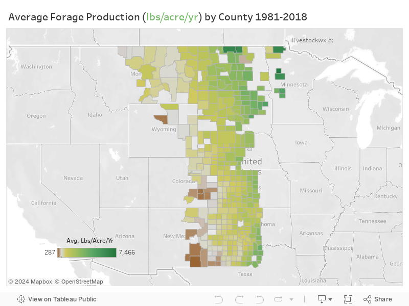
Estimated Forage Production by County
For ‘techies’ and other curious folks, Parton details how the computer models came together to create Grass-Cast…“Long term remote sensing NDVI (grassland greenness) and climate data sets (1982 to present) were available to develop the correlations of ANPP to weather variables (April to August AET). DayCent model results were used to get predictions of actual water loss by the plants for the time-period which were combined with the NDVI data.”
Grass-Cast is supported by the U.S. Department of Agriculture’s (USDA) Agricultural Research Service (ARS), Natural Resources Conservation Service (NRCS) and Northern Plains Climate Hub (NPCH), in addition to the National Drought Mitigation Center (NDMC). Scientific collaborators for the development of Grass-Cast include Colorado State University, University of Arizona, and the University of Nebraska-Lincoln.
Mouse over the interactive map to see average ANNPP for your county as well as see production for good and bad years. When combined with the Seasonal Outlook these estimates are what the Grass-Cast uses to estimate productivity.
Still Tweaking
It’s not perfect, acknowledged Peck. “Grass-Cast has some important limitations. First, it cannot tell the difference between desirable forage species and undesirable plant species, so producers need to know what proportion of a pasture is occupied by weeds and how well those weeds respond to rain (or lack of rain) compared to the desirable species. Ranchers and other rangeland managers should combine insights from Grass-Cast with their knowledge of local soils, plant communities, topography and other conditions,” said Peck, adding, “They should not rely on Grass-Cast as a sole source for making management decisions.”
Interestingly, comparing last year to this year so far much of the Southern Plains in 2018 experienced moderate-to-extreme drought (see archived Drought Monitor maps for 2018 at https://droughtmonitor.unl.edu/Maps/MapArchive.aspx), while much of the Northern Plains saw near-average or above-average precipitation and grassland production. “These very different outcomes for the Northern and Southern Plains are shown in last year’s Grass-Cast map for July 31st (http://grasscast.agsci.colostate.edu/archive).
Valuable Tool
In contrast, the spring of 2019 has been abnormally wet and cold across much of the Great Plains. Above-normal precipitation is a good thing for grassland vegetation growth in our region,” said Peck. However, abnormally cold temperatures may have caused some delays in growth. “Despite this, the most recent Grass-Cast maps suggest above-average or near-average grassland production is still possible for many areas—as long as precipitation over the rest of the growing season doesn’t drop suddenly to below-normal levels.”
As Edwards put it, “Grass-Cast helps farmers and ranchers plan, that if they get ‘this much’ rain at ‘this time,’ what might their grass production be for their livestock.” She said, “It’s a good way to put a number to it.”
For more information:
http://grasscast.agsci.colostate.edu
And:
https://www.cpc.ncep.noaa.gov/products/forecasts/
Also:
The current drought monitor:
https://droughtmonitor.unl.edu/
Amy G. Hadachek
Hadachek is a freelance writer who lives on a farm and cow-calf operation with her husband in north central Kansas and is also a meteorologist and storm chaser. She can be contacted at: [email protected]