Drought Trending for Pacific NW and the Southeast
- Chad McNutt
- May 30, 2019
- 4:28 pm
[Excerpt from the May 28th U.S. Drought Monitor]
During this U.S. Drought Monitor (USDM) week, a strong high pressure ridge was anchored over the southeastern contiguous U.S. (CONUS) while an upper-level trough dominated the West. This pattern set up a southwesterly flow across the central part of the country, which funneled moist and unstable air from the Gulf of Mexico into the Plains. Pacific weather systems moving in the jet stream flow plunged into the western trough, bringing precipitation and cooler-than-normal temperatures to much of the country from the Rockies westward.
The weather systems intensified as they moved into the Plains, triggering another week of severe weather and heavy flooding rains. Two or more inches of precipitation occurred across the Plains to Midwest and in upslope areas of Montana and Wyoming, with locally 5 inches or more. Weekly precipitation was wetter than normal across much of the Southwest, and from much of the Great Plains to Great Lakes. Half an inch to locally 2 inches was observed from the central Appalachians to New England, but these amounts were mostly below normal. The week ended up drier than normal across western Washington, northern Idaho and northern Montana, southern Arizona, most of New Mexico, and central to southern Texas. The subtropical high kept the Southeast drier and warmer than normal, with record high temperatures reported.
As a result of this weather pattern, drought contracted in Oregon, Wyoming, and the central Plains, but expanded in the northern Rockies, Texas, the Tennessee Valley, and the Southeast.
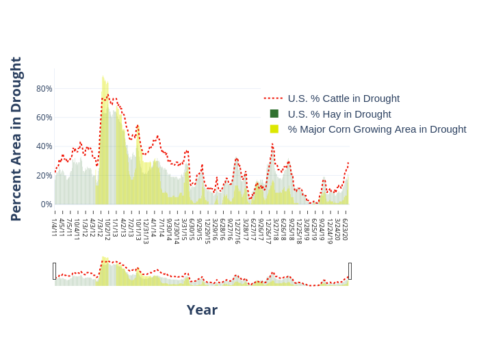
The percentage of cattle, corn, and hay in drought continues to remain low at 1% cattle, 1% hay, and no corn areas considered in drought.
1% Cattle in Drought

1% Hay in Drought

Most recent (May 28th) U.S. Drought Monitor showing areas in Abnormally Dry (yellow) or Drought (orange). Counties in blue have 50K head of cattle or great, while counties in green produce 40K tons of hay or greater.
Interactive chart showing cattle, hay, and corn areas in drought since 2011. Mouse over the chart to see individual years.
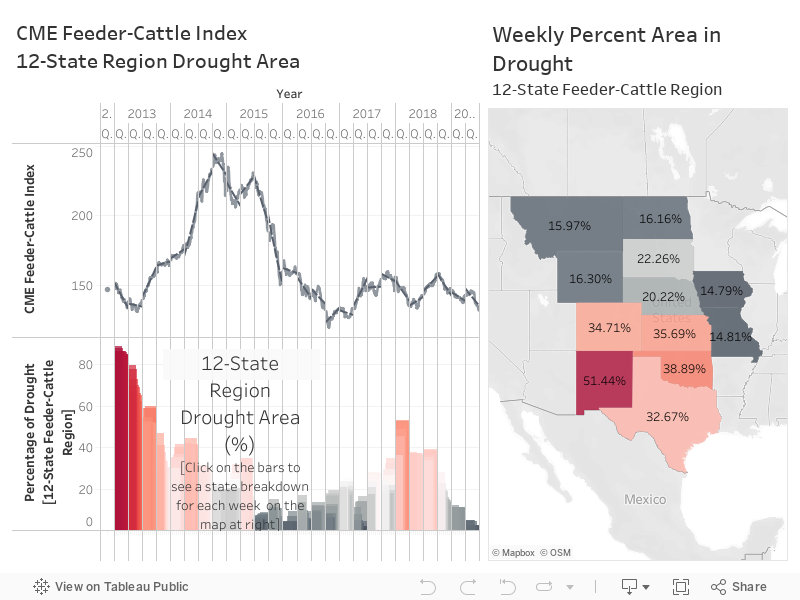
Drought & CME Feeder-Cattle Index
This week we have a new analytic that shows the CME Feeder-Cattle Index against the percentage of drought based on the U.S. Drought Monitor across the 12-State Feeder-Cattle region. The data in the below chart go from 2013-present. The CME Feeder-Index shows the 7-day weighted average price (cwt).
You can interact with the chart by using your mouse to see the data for specific dates. Click on the bars to see a breakdown of the 12-states on the map at right.
There are of course many things that can influence the Feeder-Cattle Index and drought is just one of them. We don’t necessarily see a trend (other than following the massive drought in the Southern Plains from 2011-2015) but we thought it was still interesting to see the data and play around with the chart. Hope you enjoy it too!
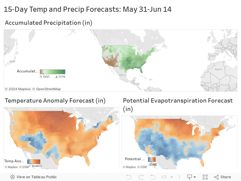
Potential Areas of Drought Improvement and Deterioration
The below maps show the 15-Day Accumulated Precipitation, Temperature Anomaly and the 15-Day Potential Evapotranspiration Forecasts. Potential Evaportranspiration, or PET, is the amount of evaporation that would occur if sufficient water is available. Basically, you can think about it as the amount of water that could be evaporated from the soils and plants (if water was not limited, which is why it has “Potential” in the title).
The Southern Plains/Central U.S. will see some rainfall in the next two-weeks. The largest totals could be close 4″ in Oklahoma and Kansas…places that don’t need it. Temperatures will mostly be above-normal for the Contiguous U.S. The highest departures will be in the Northern Plains. Potential evapotranspiration rates will also be highest in the Northern Plains.
We could see some drought deterioration in the Southeast and the Pacific Northwest. Washington state continues to see Moderate Drought for about 43% of the state. Yakima, Kittitas, and the surrounding counties in Washington in particular could see drought deterioration over the next couple of weeks.