Late March was extremely wet, and so far, early April has continued that trend. The April 11th release of the U.S. Drought Monitor set a record for the lowest percentage of drought since the Drought Monitor started in 2000.
So far in April, we have seen improvements in the Pacific Northwest and local flooding in areas that had been only recently considered in drought. The South and Southeast have been going in and out of drought but we think this will improve over the next couple of weeks (see below on the 15-day forecast). Locally heavy rainfall brought improvements to parts of South Texas, Louisiana, and the Carolinas. The rest of the U.S. remains largely free of drought and abnormal dryness.
Cattle in Drought
0%
Hay in Drought
0%
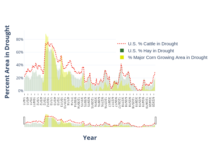
The percentage of corn, cattle, and hay that are considered in drought continues to stay low. This week finds 2% of cattle, 2% of hay, and 0% of corn in drought.
Interactive chart showing cattle, hay, and corn areas in drought since 2011. April 9th is tied for lowest percentage of cattle, hay, and corn in drought since stats started to be tracked.
Potential Areas of Drought Improvement and Deterioration
The below images show the current U.S. Drought Monitor and the 15-Accumulated Precipitation Forecast. The eastern half of the U.S. could be very wet over the next two-weeks and could see large improvements in the areas considered in drought. Drought deterioration could be seen in South and West Texas along with parts of New Mexico.
April 9, 2019 U.S. Drought Monitor. Counties shaded in purple have cattle densities of 50K head or more.